


Here is some useful information for those who wish to visit Cappadocia...
Some sixty thousands years ago, during the Tertiary Period (interval of geologic time lasting from approximately 66 million to 2.6 million years ago), the Taurus Plateau (the mountain complex separating the Mediterranean coastal region from the central Anatolian Plateau) was formed while the rock layers were forced upwards by creating huge cracks in the land and a series of volcanoes.
Hasandağ and Erciyes, the two largest volcanoes of the region, erupted constantly, burying vegetation and animal life under a deep level of lava and spraying ash over an area of many square kilometers between the cities of Nevşehir, Niğde, Kayseri and Konya (A Roman coin minted in Caesarea/Kayseri depicts Mount Erciyes erupting, although the volcano is thought to have become extinct long before, which make one think that the legend survived through the ages).
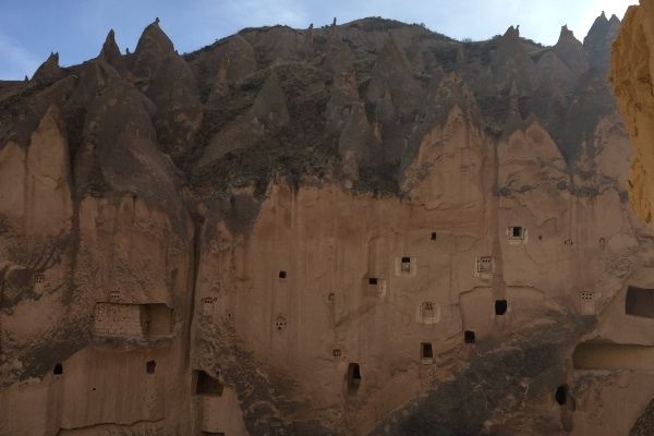
Because of the eruptions, the entire area was covered with soft volcanic rock. Thus, this terrain was exposed to the influence of the elements due to the lack of protective soil or vegetation. The effect of extremes of temperature caused the hard basalt crust below the volcanic rock layer to crack. Rainwater poured into the cracks through the layers in addition to the effects of the wind and changed the face of the landscape by creating thousands of strange looking pillars, conical towers and ravines that are called as “fairy chimneys” by the locals in every shade from pink through yellow to russet browns.
Cappadocia History
Men discovered that dusty volcanic soil became fertile, when irrigated, causing many peoples and civilizations come and go through this region throughout history. The first settlers were Hattians during the 3rd millennium BC, followed by the Hittites, who merged with the native populace, at the beginning of the 2nd millennium, but was broken up into small kingdoms when defeated by the Gimmirrais in 1200 BC. After the Hittites, Scythian and Assyrian rules are dominant until the Medes, who formed an alliance with the Babylonians and then defeated Assyians, invaded Anatolia in 1000 BC. In the wake of Medes, Persians retained their hold in Cappadocia. Although Persians were defeated by Alexander the Great in 334 BC Cappadocia never came under the influence of the Greek dominated cultures of the coastal countries of Lydia, Phrygia, Paphlagonia, Caria and Cilicia. The Persians separated the area into two, naming the southern half as “Greater Cappadocia” and the northern part as “Pontic Cappadocia”.
Romans conquered Cappadocia in 17 AD and built a road linking the region to the Aegean coast, thus fostering trade and communications with the other parts of the world.
Around 200 AD the Christians of Anatolia began to settle here. In 395 AD Cappadocia became part of the Eastern Roman Empire of Byzantium. In the meantime, Sassanids were in the meantime a constant harassment to the Romans and Byzantines.
Men have hollowed out troglodyte dwellings in this soft rock over centuries as the tuff peaks were ideal refuge spaces in this region. During the dawn of Christianity, the early Christians made countless cave churches and monasteries as well as underground cities where they could shelter from their persecutors. They even continued to live in these after Kayseri became the center of Christianity in 600 AD,
Sassanids were finally defeated by the Arab army under the Caliph Omar in 637. This time Umayyads began incursions into the region. Thus, the region came under the Islamic influence. Again, under this influence, iconoclasm spread widely in the Byzantine Empire. Christian communities seeking refuge from iconoclasm settled in the labyrinthine Cappadocia terrain, where they carved secret churches out of rock.
The descandants of the Oghuz Turks from the east stepped up their incursions into Anatolia in the 11th century by winning the Battle of Manzikert against Byzantines in 1071, which opened the door to mass Turkish migrations into Central Anatolia. Thus the Seljuk Empire was established, reaching a peak of cultural development and political power under Sultan Alaeddin Keykubat I in the 12th century. The period following the downfall of the Seljuk Empire in the 13th century up until the Ottoman Empire established a definite supremacy in the 15th century was racked by turmoil and strife, as the invading Moghuls wreaked havoc in Anatolia.
After the occupation of Turkey by the Allies following the World War I and collapse of the Ottoman Empire Cappadocia became the part of modern Turkey.
Cappadocia was first discovered by western travelers at the beginning of the 18th century. Paul Lucas (1669-1725), who was appointed by the French king Louis XIV to travel east, arrived in Istanbul first in February 1705 and then to Kayseri in August. Being fascinated by the geographical structure of Avanos and Ürgüp, he wrote, “there are over twenty thousand pyramid-shaped rocks in which houses are hallowed out”. He referred to the rocks which balance on their peaks as “a woman holding a child in her arms, a lion, a sphinx. His imagination of these is seen in one of the engravings, which illustrate his travels. Lucas was criticized by the skeptical German writer C.M. Wieland, though, who said that, “it is impossible to believe that so many pyramids hollowed out into houses could possibly exist”.
In the 1830s this time a French architect Charles Texier traveled extensively in Asia Minor and he devoted one of the chapters of his six-volume work where he published an account of his travels to Cappadocia, its geography and history only. The book was illustrated with engravings of the geological formations of the region by Lemaitre.
In 1939, W.J. Hamilton, the general secretary of the British Geological Society, said in his account of journey published in 1842, “No country in the world has a structure so interesting to the geographer, historian and antiquarian as Anatolia. Words are not adequate to describe the appearance of this extraordinary place”. It was Hamilton, who first described the ruins of Göreme and the Soğanlıdere Valley.
In the first half of the 19th century, another traveler who came to the region on behalf of the Royal Geographical Society and the Society for Promoting Christian Knowledge in Chaldea was W.F. Ainsworth. He was the first to study the Red Church at Sivrihisar and the Ihlara Valley. He also gave dramatized description of Cappadocia, “As we emerged from the river valley we found ourselves suddenly in a forest of rock cones and pillars which surrounded us in infinite confusion. We seemed to be walking in the ruins of a very ancient and large city. On top of some of the cones were large lumps of rock. Some of these had fantastic forms, one resembling a lion, another huge bird, and others a crocodile or fish.”
Further to such a rich historical background Cappadocia has now been a site of major touristic interest, both through its Christian art and the natural phenomenon behind the “fairy chimneys”.
Cappadocia and Environs
Nevşehir, the administrative center of Cappadocia, is the largest town with the ruins of a Seljuk and later Ottoman castle, Kaya (Rock) Mosque from Seljuk times, the Kurşunlu Mosque that was built by the Grand Vizier Damat Ibrahim Paşa in 1726 including a medrese (theological school), a hospice and a library.
Almost all of the surrounding land of Cappadocia is arable and, accordingly, a great deal of people are engaged in growing wheat, potatoes, onions, barley, sugar-beets, grapes, melons and apricots.
Ürgüp and Göreme are amongst the outstanding sites in Cappadocia.
Göreme National Park and Cappadocia were inscribed on the UNESCO World Heritage List in 1985 with its 7 locations as follows:
1- Göreme National Park
2- Derinkuyu Underground City
3- Kaymaklı Underground City
4- Karlık Church
5- Theodore Church
6- Karain Columbaries
7- Soğanlı Archaeological Site
 |
Göreme Valley is a unique design of nature with slopes capped with rock formations so called as fairy chimneys, rich water sources, abundant flora, rock-cut and frescoed churches.
Cappadocian valleys were formed from the hardened tuff of the lava that went out of the extinct volcanoes of Erciyes (3.916 meters/12.850 feet) and Hasan (3.253 meters/10.673 feet) Mountains, which eroded by sand and water erosion through millions of years while the area became the seat of several civilizations over the centuries since the Chalcolithic Era (5.600-3.200 B.C.). Quite a few of underground cities, used as sanctuaries for a long time, are present in the area and these enchanting and partially revealed subterranean Cappadocia cities are known to have deeper levels still awaiting to be explored.
Not only fairy chimneys or rock cut sites, but also the finest examples of Seljuk and Ottoman work of art and architecture are encountered in Cappadocia. Here are some of them:
1- Eğri Minaret
2- Alayhan
3- Sultanhanı and Sarıhan
4- Taşkınpaşa Mosque-Ürgüp
5- Sungur Bey Mosque
6- Alaaddin Mosque
Agzi Karahan Caravanserai (Hodja Mesud Inn)
This is a caravanserai (a roadside inn where travelers could rest and recover from the day's journey) built in 1231-1239 during the Seljuk era and located on the road between Aksaray and Nevsehir.
During the middle ages there used to be caravanserais in this region at every 40 kms (25 miles), a distance that could be taken in 9 hours on the camelback. They were used in both winter or summer times. They served as both inns and fortresses as they also provided shelter for the goods in transport.
The decoration on the portal of the inn represents the typical Seljukian work of art. The first courtyard was used in summer time by both humans and animals. The winter part was built in 1231 during the reign of Alaaddin Keykubat while the summer portion was added in 1239 during the reign of Giyaseddin Keyhusrev II. According to the scripture at the gate of the winter part, the inn was built by Hodja Bin Abdullah.
There is a mesjid (small mosque) in the middle of the courtyard. Once there was a fountain under the mesjid. Inside the mesjid there is a niche (mihrab) with muqarnases on the top showing the direction of Mecca. The windows are very small for security reasons and added only to let the sunshine in.
In the covered part there are also lodges reserved for the use of dignitaries and caravan owners.
On the way to Nevşehir there are two more caravanserais recently restored; Öresin Inn (Tepesi Delik Han) and Alayhan near Acıgöl having a volcanic crater lake nearby.

Avanos
Avanos, also referred to as Venessa in the antiquity, is located 18 km north of Nevsehir and is sitting on the shores of Kızılırmak River (Halys as standing on the Bible). It's been a settlement area since the Bronze Age (3000 B.C.) and is mentioned in the Assyrian and Hittite tablets. Today there are still traces from the Roman, Seljuk and Ottoman periods. Amongst the architectural structures are Yamanlı Mosque, Alaaddin Mosque, Stone Bridge and Ottoman houses while the town is especially renowned for its pottery thanks to the Kızılırmak River, which flows into the Black Sea and brings fertility to the land for thousands of years.
The pottery tradition in Avanos dates back to the Hittites and is still one of the main source of income for the inhabitants. The red clay and silt brought by the river is the main raw material of potter's clay and they are shaped in the hands of the skillful artisans. This traditional profession has been handed down from father to son over the centuries and today the town of Avanos is still full of pottery workshops.
 |
 |
Belisirma
Belisırma Village, which is the extension of the Ihlara Valley, is located by Melendiz Stream offering a nice break whilst touring.
This village in Güzelyurt Province has been inhabited since pre Seljuk period in the 13th century. The name means "the beautiful landscape" in Greek language. There are historical churches like Ala Church and Direkli Church in the village.
The residents of the village deal with agriculture, vinegrowing and animal raising to make their living.

Derbent Valley
Amongst hundreds of valleys in Cappadocia Derbent Valley outstands with the rock formations, or fairy chimneys as named by the locals, resembling the shapes of various animals as well as humans. One of the most interesting ones is a rock mass that is likened to a camel. This valley is also referred to as Dervent, Pink or Güllüdere Valley in different sources.
 |
 |
Derinkuyu Underground City
Derinkuyu is the largest underground city in Cappadocia covering an area of 4 square kilometers while the cleaned area so far is 2.5 square kilometers. Its residential floor and water well reach a depth of, respectively, 40 and 60 meters. There are 52 ventilation shafts in it. Today eight floors can be visited, but it is estimated that there are 12 floors in total. The underground city supposedly has an accommodation capacity of 3 to 5 thousand people.
The entrance floor is thought to date back to proto-Hittite period and was heavily used during war times in the Roman and Byzantine periods to hide. During the course of time, the city expanded with the openings of new tunnels leading to deeper points in respond to the increase of the population. At the entrance there is a stable while there are also a church, a winery, a missionary school, a burial vault, a kitchen, a cellar, storerooms, workrooms, living rooms and bedrooms in the lower rooms connected through tunnels.
The floor systems of Cappadocian underground cities are different than those made today and the cities had been built on fairly complex plans. The floors do not succeed each other downwards and they are not connected with the same corridors and stairways.
There seems to be a tunnel leading to the other underground city, Kaymakli, which is 15 kms far from this place. However, it is not excavated as yet. There are also tunnels connected to the nearby houses.
 |
 |
Goreme Open Air Museum
This area is of great importance as it is the place where the monastic education had begun during the early Christianity period. The churches, chapels, monasteries and refectories that were carved into the rocks are dated to the 4th-13th centuries. Most of the geometric designs date back to late 8th-9th centuries while the most elaborate ones are from the 10th -13th centuries.
These early Christians of the area employed two different techniques on the wall paintings. In the first technique, the scenes were painted directly on the leveled walls without adding any other layer while in the second technique they were painted on layers prepared with materials such as straw and egg. As the depictions of Jesus Christ and Apostles had been prohibited during the Iconoclastic Period (726-843) some symbols like cross, fish and palm tree were also painted during that time. Churches built after Iconoclastic Period display dazzling frescoes.")
1-The Nuns Convent, 2-St. Basil Church, 3-Apple Church, 4-St. Barbara Church, 5- Snake Church, 6-Unidentified Church,
7-Refectory, 8-Dark Church, 9-St. Catherine Church, 10-Sandals Church
The Monasteries of Nuns and Monks
The large rock mass located on the left after entering the museum is the Monastery of Nuns dating to the 11th century. This 6-7-story monastery includes chambers, a refectory, a kitchen and a small chapel. Next to it is another structure which was the Monastery of the Monks, which suffered a serious collapse due to erosion.
") |
") |
Apple Church
Apple Church was probably built around mid 11th century and early 12th century. It is erected on a ground plan having the shape of a Greek cross covered by cupolas seated on independent supports and having three apses.
There are two different claims with regards to the name of the church. Some historians think that it has taken the name from the surrounding apple trees while some likened the round figure in the hand of Archangel Michael* to an apple though it should probably refer to the globe (See below). There are 15 holy scenes altogether. The paintings on the layers beneath the frescoes mainly consist of patterns.
*Archangel Michael was first seen as a healing angel during the 4th century in the Catholic sanctuaries, who was afterwards deemed as a protector and the leader of the army of God against the forces of evil.
") |
") |
Saint Barbara Church
The most distinguishing feature of this edifice is the tile red motifs. A great deal of the interior space is decorated with various reddish figures such as birds, crosses, mythological animals, plants, geometric patterns, symbols and parallel lines which gives a “cut stone wall” impression. According to some historians who claim that there is no any Cappadocia churches from the Iconoclastic Period these figures that have been dyed with ochre pigments represent a kind of magic aimed at evicting demons and providing protection from evil. On the walls there are also depictions representing St. Barbara, St. George and St. Theodore.
") |
") |
Snake Church
It is architecturally different from the other churches as there are no domes and columns as in the other ones. There is also a section of tombs covered with a flat ceiling next to the main rectangular space. The church derives its name from the fresco on the left wall from the entrance. Here the mounted Saint George and Saint Theodore are depicted fighting against a dragon-shaped snake. Emperor Constantine and his mother Helena holding the “cross” are depicted on the right side of this scene.
On the right side from the entrance there is another fresco with three figures; Saint Onuphrius behind a palm tree, Priest Saint Thomas canonizing and Cappadocian Saint Basil holding the Holy Scripture. This fresco depicts the legend of Onuphrius. There are two legends in this regard.
According to the first one, he was originally from Syria and spent 60 years of his life in the deserts by eating only date and plants. Saint Paphnutius who wandered the deserts to investigate the lives of Hermits, Christian anchorites living in Egyptian deserts in the 1st century A.D., stayed with him until his death. Saint Onuphrius is regarded as the symbol of self-denial and truthfulness, and he is commemorated with religious ceremonies held on June 12 every year.
The second legend takes Onuphrius as a female. She invoked God to change her, when she became uneasy against the interests of men. Her prayers were answered and she became ugly with a beard growing on her face. On the basis of this story, Onuphrius is always depicted as an androgynous person.
") |
") |
The Refectory
The three adjacent chambers located between Snake Church and Dark Church was used as the Larder, the Kitchen and the Refectory. The foods gathered in the region were stored in the niches of the Larder. As seen on today’s Anatolian villages the tandoors and ovens were used.
The huge stone table could easily seat 30 people. The head of the table was always used by the high priests (Abbots). The grapes were placed in the pit on the ground and were pressed to transform them into wine.
The whole of this spur of rock is honeycombed with the passages and chambers of the monastery, and here and there, the large stones used to block the narrow entrance in times of danger can still be seen.
") |
") |
The Dark Church
The reason why it is called Dark Church is the lack of daylight inside with only a small window and therefore it is one of the best preserved churches with vivid colors of frescoes. It is dated to the 12th-13th centuries and originally was the part of a monastery. There is also a tomb chamber at the entrance of the church. This church can be visited with an extra cost.
") |
") |
") |
") |
-The Pantocrator
It means “Almighty, All Powerful, Ruler of All” in Greek, used by Apostle Paul to describe the Lord, and is one of the most common religious images of Orthodox Christianity. It generally occupies the central dome of the church and half dome of the apse or the nave vault.
-The Betrayal
This scene depicts the betrayal of Judas. When Christ went to the Mount of Olives together with his disciples he encountered a crowded group with sticks who had been prepared by Judas saying that the one he will be kissing is to be Jesus Christ. In the scene, Judas is depicted on the foreground embracing Christ while the figures on the background represent the angry group.
") |
") |
-The Transfiguration
When Jesus Christ went to the mountains together with James, John and Peter he felt that he was going to die before the Crucifixion and told this to the prophets Elijah and Moses. Then Jesus began to shine with bright rays of light and therefore Jesus is always portrayed in rays of light in Transfiguration scene while the three figures hiding themselves at the bottom symbolize James, John and Peter.
-The Crucifixion
Jesus is being crucified in Mount Calvary, a hill outside ancient Jerusalem
The Chapel of Saint Catherine
The reliefs and geometric motifs on the wall attract the attention in this chapel dating to the 11th century. There are 11 tombs in the ground of the chapel.
") |
") |
The Sandals Church (Çarıklı Kilise)
This is the smallest one among the colonnaded churches in the Göreme Open Air Museum. Some say its name is derived from the footprints on the ground attributed to Jesus Christ while others claim the footwear of the saints depicted in the frescoes (Under the Ascension) was likened to sandals by the local people. There is also a small refectory on the lower floor of the church.
") |
") |
-The Nativity
This scene exhibits the infant Jesus, his mother Mary along with her husband, Joseph, as well as shepherds, sheep and angels near the manger in a barn.
The Buckle Church (Tokalı Kilise)
This one, located on the direction of Göreme town outside the Open Air Museum, is the largest one in the area and deemed as a “cathedral”. It has three sections with complex and eclectic architecture built on three different periods. It was used from the 10th century until the early 13th century. The paintings on the arch of the narthex and the walls of the nave date from the 13th century. They represent the life of Christ from the Annunciation to the Ascension with great liveliness and detail. Among the many saints depicted here, are St. Basil, a native of the area and Bishop of Caeserea (Kayseri) and St. George, traditionally associated with Cappadocia.
") |
") |
Gülşehir
Gülşehir (Rose City), originally named as Zoropassos and then Arapsun during the Roman Empire is situated on the southern bank of Kızılırmak (Red River / Hallys). Though being a small town with only some 30 houses, the Ottoman Grand Vizier Mehmet Seyyid Pasha has commissioned to be built a complex here including a mosque, madrasa (theological school) and a fountain. In the environs of Gülşehir are also Civelek Caves, Büyükkale Churches, Açıksaray, Kızılkatma, Karşı Church, Saint Dimitri and Karavezir Hamam (Bath).
The village is notable for its formations with interesting facades resembling mushrooms, trees and human faces.
Açık Saray (Open Palace), covering an area of one sq km and eight complexes gathered around three-sided courtyards, is located on the 15th km on the Nevşehir-Gülşehir road and contains Roman rock-cut churches dated to the 9th and 10th centuries. Its monastery building is interesting.
The first complex on the right of the entrance has one of the most outstanding façades in the whole of Cappadocia. It has 3 rooms, two of them having irregular rooms while the other having a rectangular one in which a large cross is carved on the interior wall above the entrance. The bull motif, regarded as sacred in Neolithic cultures as well as in Hittites, can only be seen in this place in Cappadocia.
Karşı Church (St. Jean Church), built in 1212 and restored in 1995, is very close to the entrance of Açıksaray Archaeological Site and has frescoes with different original styles. In this small two-storey building, all of the predominantly light yellow and brown frescoes were painted on dark-colored surfaces. The niches and facades are decorated with geometric motifs as well as frescoes with scenes from the Bible. On the west and south walls of the church is the “Last Judgment” scene, a rare example amongst Cappadocian churches. The other scenes; “Deesis” on the apse, the “Annunciation” in its front, bird designs below, portraits of the saints in medallions on the barrel vault, “Last Supper”, Betrayal by Judas” and “Baptism” on the south wing of the vault below Koimesis (Falling Asleep of Mother Mary), “Descent from the Cross” and “Women at the Tomb” on the north wings of the vault.

Haci Bektas Museum
Hacıbektaş, 45 km (28 miles) far from Nevşehir, derived its name from Haji Bektash Veli, a Muslim thinker, philosopher, mystic and founder of Bektashism. He was born in Khorosan, Iran, in the 13th century, and then moved to Anatolia during the rule of the Seljuks and died there. He earned respect of not only the Muslim community, but also of the Christians with his life philosophy, faith, truthfulness, plainness, culture and spiritual richness.
The Dargah of Hacıbektaş built in 1519 and his tomb is the part of the museum today. Inside the large building complex there is a mosque, refectory, a guesthouse, a kitchen, a laundry, a fountain and the tomb.

Ihlara Valley
Like the other parts of Cappadocia region this area, also called as Peristrema, was also formed by the volcanic layer shaped by wind and water while this valley is somewhat different as the Melendiz Stream flowing through has created a narrow and deep canyon, which is 14 kilometer long and 150-200 meter deep. The valley has quite a few hidden places, offered an ideal place to priests and hermits as a shelter and worshipping place in their religious activities since the 4th century A.D. There are more than 100 churches in this region.
 |
 |
Kaymaklı Underground City
This is the most important underground city along with Derinkuyu Underground City as they both give apparent hints about underground life and their sizes. The inhabitants of Kaymaklı Village, which was named as Enegüp in the past, are connected with the underground city though some 100 tunnels as almost all the houses were built on the mouths of these tunnels. These tunnels are used as storerooms or stables as was the case thousand years ago.
The first four floors of the underground city can be visited today. The passages are narrow and low and therefore two persons cannot walk side by side. There are well marked signs showing the directions, but not recommended for those with claustrophobia, nyctophobia and bathophobia. Within the city there are water wells, winery, sitting rooms and a church.
By the entrance, at the first floor, is a stable with its watering through and mangers. The gate with a sliding stone on the wall of the stable leads to the second floor where there is a church with a baptismal font. Next to the church there are tombs that probably belonged to the clergy of the city. Behind the church are the living rooms. Kitchens, wineries and storerooms can also be seen around. On the refectory floor there is a 57-hole andesite stone in which metals - especially copper - were melted and also another mortar stone.
 |
 |
Keslik Monastery
This monastery, located in Cemil Village, is one of the most important Christian religious buildings in the south of Mustafapaşa (Sinassos) along with Theodora Church in Yeşilöz Village. Keşlik Monastery, also known as Archangelos, contains two churches, a school, a kitchen and a winery.Some 200 Christians were supposedly living in this building complex. It has frescoes dating from the 13th century.
 |
 |
Nigde
The Alaaddin Mosque is a fine example of the Seljukian architecture while the Sungur Bey Mosque was built during the Mongolian period (1335). The octagonal Hatun Türbesi (1313) is also interesting example of Seljukian decorative stonework with carved flowers and animals on the exterior. Gümüşler Monastery, cut into a rock, has very fine and well preserved frescoes from the 12th century.

Ortahisar
Ortahisar, similar to Uçhisar in shape, is located on the foot of a huge rock formation and interesting with its traditional stone houses and old neighborhoods. The chambers and passages that can still be seen today inside this stone mass had been used for protection and sheltering by Christian communities. The natural cold storage rooms that had been used during the Byzantine period are still used these days to store fresh fruits and vegetables, especially citrus fruits such as oranges and lemon brought from the Mediterranean region.
Paşabağı
The fairy chimneys in Paşabağı along with the neighboring Zelve and Derbent have quite different shapes; they are like original statues. Some of them are pointed while some others have caps and three heads. Paşabağı was formerly called as “Valley of Priests or Hermits” as it had been inhabited by hermits. This area was an important training center until the 13th century. It was inhabited until 1952.
The most striking example is the Saint Simeon (Symeon) Chapel. It is believed that Saint Simeon of Aleppo had lived in this three-headed fairy chimney during his seclusion. The steep stairways inside the huge rock lead up to the cell of the hermit. As in many other places of the world Cappadocia monks also lived in seclusion without meeting anybody for many years and contended themselves with the water and bread left in front of their doors while they slept on their stone beds in their cells illuminated by narrow windows.
 |
 |
Rose Valley (Kızılçukur) & Çavuşin
The long walking tracks between Kızılçukur, Güllüdere, Akvadi and Cavusin offer excellent opportunity for those who would like to see the off-road vantage points. Çavuşin is one of the oldest settlements in the region while the life in the rock formations had continued until 1960s when the village was abandoned because of the rocks falling down due to erosion. There is an ongoing project to revive the village.
The most important structure in Çavuşin is the Nicephorus Phocas Church (Çavuşin Church), known to have been built in the 10th century for the Byzantine Emperor Phocas who defeated the Arab armies.
At the end of the rocks on Çavuşin hill is another spacious construction named Basilica of St. John or John the Baptist, built in the 5th or 6th century. The large courtyard in the front side of the church was demolished by the rocks that fell due to erosion.
There is also a small and snow-white mosque amongst the rocks in the center of Çavuşin, which is still open to worship. The miniature mosque with its four-columned stone minaret, single-unit interior space and the single plant motif on a column, was repaired in recent years.
") |
 |
Saruhan Caravanserai
One of the most typical examples of the caravanserais built by the Selcuk from the 10th on is Saruhan that is situated near Avanos. It was built in 1249 by Seljuk ruler Kaykaus II and covers an area of 2000 sq meters. The two-colored stones placed around the doors of the structure, made of well-cut stones and which is dominated by earth tones and yellow, create a distinguished outlook. In accordance with the architecture of the caravanserai, the facades bear predominantly geometric motifs, and the whole structure reflects a minimalist decorating style. Saruhan is the last caravanserai built by the Seljuk sultans.

Selime (Güzelyurt)
This is one of the most interesting places in Aksaray region of Cappadocia with its stone houses, churches, underground cities, rock-cut mosque and valley of monasteries. This district was previously called first Karvali and thereafter Gelveri. The important Orthodox saint, Gregory of Nazianzus, lived there. Bucak (Saint Anargiros) Church, Buyuk Kilise Mosque (Big Church / Saint Gregory Church), Saint Mamas Monastery, Kızıl (Red) Church, Halvadere (Mokissos) remains, Ilısu Thermal Springs and Ilıca Valley are among the places of interest.

Sinasos (Mustafapaşa)
Sinasos, as it was called earlier, was a summer resort of Istanbul Greeks in the Ottoman period. Especially those dealing with caviar trade in Istanbul built beautiful houses in Sinasos, where they were spending the summer. Sinasos was evacuated in 1924, though, like the other Anatolian locations during the population exchange agreement. After the Greek people migrated to Greece the village’s name was changed to Mustafapaşa while this once popular wealthy village transformed into a ghost town until the touristic value was explored.
The houses between the slopes and the lower parts of the village are intertwined with rocks. In some houses, back rooms beginning inside rock are complemented outside with walls made of stones from local quarries. Most of the houses with generally a courtyard are constructed with traditional stones, which reflect a wonderful stone workmanship. All the houses have kitchens, ovens, storerooms and sections for making wine and syrup. The doors and windows are made of wood whereas window guards, handles and knobs are made from metals. The parts above the doors, window borders and cantilevers between the floors attract attention with their relief motifs. These stone decorations stylize fans, badges, stars, whirligigs and various plants.
One of the most impressive examples of the civil architecture in Mustafapaşa is the Mehmet Şakir Paşa Medrese dating to 1890.
") |
") |
Soğanlı Valley
Soğanlı Valley, located in the Yeşilhisar district of Kayseri and 50 km far from Nevsehir, is similar to Ihlara Valley with its more than 100 churches and dovecotes spread on the rocky slopes. It is known for its rag dolls. Most of the cavities hidden inside the rocks in the valley house a church or a burial chamber. Yılanlı, Tokalı, Karabaş and Tahtalı (Saint Barbara) churches are amongst the most important ones.
 |
 |
Kubbeli (Domed) Church
Kubbeli (Domed) Church, a Byzantine structure dated to the 14th century, is one of the interesting churches with its look resembling a miniature chateau on a huge rock. Its exterior form was shaped from the tuff layer. It has two storeys with its columns and traces of frescoes.
 |
 |
Saklı (Hidden) Church
Next to the Domed Church is the small Saklı (Hidden) Church, resembling a mausoleum, with its three chambers. There are no remarkable frescoes or decorations, though.
 |
 |
Tokalı (Buckle) Church
Located on the right side on the entrance to the valley, the church draws the attention with its steps formed by the steep rocks on the slope. It was restored in early 1980s while its frescoes date back to the 9th, 11th and 12th centuries. The interior space consists of four parts.
 |
 |
Yılanlı (Snake) Church
It is carved under a large rock. It has a courtyard and sections such as the kitchen, dining rooms, burial chambers and corridors. It takes its name from the fresco depicting Saint George killing the snake.
 |
 |
Uçhisar
Uçhisar is a settlement built on the tallest hill in Central Cappadocia. Its fortress, which is 80 meters high and looks like a large rock from distance, can easily be seen from many valleys. There are carved small rooms, indented surface in this texture that changes color during the day. When the weather is clear, there is an excellent view of the Mount Erciyes, located 80 kilometers away.
At the foot of the Uçhisar Fortress is Pigeons Valley, leading to Kızılırmak River. On the slopes of the valley there are many dovecotes, carved out by people to collect the manure of the doves, which are used in viniculture. By the doors of the dovecotes there are also some ornaments dyed in ochre. These might have been drawn to draw the attention of the birds.
Zelve Valley
Zelve Valley, located near Paşabağı, mirrors the life of hundreds of years ago with its religious buildings such as churches, monasteries and mosques along with a mill, tunnels and a square. Zelve, which is continuing to be exposed to landslides due to the erosion, consists of 3 valleys. The first valley contains the Üzümlü (Church with Grapes) and Balıklı (Church with Fish) Churches, the Seten (a mill to produce bulgur) and a juice house. In the second valley, which is connected to the third valley through a long tunnel, is the Holly Cross Church. The most important structures of the third valley are the Monastery Complex, the rock-cut mosque and the Direkli (Pillar) Church.
There seems to be a tree growing upside down in the Monastery. This is a Tuba Tree, often associated with a tree that Muslims belive grows in the Heaven.
The dovecotes, which looks like a different painting, carved into high rocks also draw the attention of the visitors.
Zelve Valley was partly inhabited until early 1950s as having vineyards. However, the villagers were then evacuated due to the risk of erosion. Therefater, the valleys were opened to the visitors in 1967.
 |
 |
Shopping in Cappadocia
Cappadocia area is a good centre to buy woven rugs and beautiful carpets colored with natural dyes that are still made at the neighboring town of Kayseri. Avanos town is also known for its pottery and onyx shops. Amongst people onyx is known as marble. Hacıbektaş and Tokat are also known for onyx production.

